

Wayanad, Tunnel Project, Warnings from Government Data and the 2025 “Sliding Earth; Scattered Lives” Study

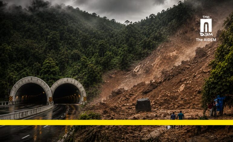
As Wayanad reels from yet another devastating landslide, this time at Kallady, adjacent to the proposed Anakkampoyil–Meppadi Tunnel project; a fundamental question can no longer be ignored: should large infrastructure projects continue in one of India’s most ecologically fragile mountain landscapes? Drawing on the findings of the 2025 Transition Studies initiative, “Sliding Earth; Scattered Lives”, environmental and Social Activist K. Sahadevan examines the scientific, ecological and social risks surrounding the tunnel project.
He argues that the warnings are neither speculative nor new; they are grounded in official records, expert assessments and the region’s repeated experience of disaster. The issue is no longer whether Wayanad is vulnerable, but whether governments can continue to ignore what the mountain itself has been telling us.
Wayanad has once again been struck by a devastating landslide. This latest disaster occurred in Kallady, right next to the construction site of the proposed Anakkampoyil–Meppadi Tunnel. The need to reconsider large-scale infrastructure projects in light of Wayanad’s extreme environmental vulnerability has been evident for decades. A recent study published in 2025 by a team of approximately ten scientists under the Transition Studies initiative titled Sliding Earth; Scattered Lives reinforces this urgent concern. In the context of recurring disasters, it is imperative to seriously examine the additional risks and potential catastrophes that the Wayanad tunnel could trigger in this ecologically fragile region.
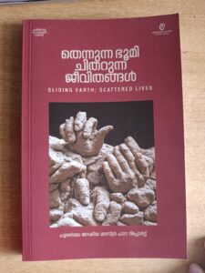
The Dimensions of the Anakkampoyil–Meppadi Tunnel
The construction of the Anakkampoyil–Meppadi Tunnel, connecting Kozhikode and Wayanad districts, was inaugurated by the Chief Minister of Kerala on 5 October 2020. At the inauguration, the Chief Minister stated that the tunnel would significantly reduce travel time between Kozhikode and Wayanad, better integrating the highland district with the rest of the state. He assured that the project would be completed within three years.
The 8.6-km-long tunnel passes through ecologically sensitive areas, including the 7,500-foot-high Vavulmala in Kozhikode district and Chembra Peak in Wayanad. Yet, at a time when expert committees are actively working to protect the Western Ghats, issue recommendations, and notify buffer zones, India’s third-largest tunnel cutting through this fragile mountain range is being advanced without comprehensive scientific studies.
The government has proceeded without clarifying how the tunnel might affect the numerous springs and tributaries that flow from the Western Ghats into the Chaliyar River, or what the broader environmental and social consequences will be. During the inauguration, the Chief Minister declared that “no one will be allowed to obstruct development.” This raises a fundamental question: what authority does a government, elected for a mere five-year term, have to compromise the long-term ecological sustainability of a region and its people through projects with potentially irreversible impacts?
Given the high risk of landslides and phenomena such as soil piping in this area, the project should proceed only on the basis of thorough scientific studies and transparent public debate. Regrettably, the government has taken no such steps.
Tunnel Road: Project Details
The Kerala Public Works Department has applied for environmental clearance for a unidirectional (2+2 lane) double tunnel to provide a direct route between Anakkampoyil in Kozhikode district and Kalladi–Meppadi in Wayanad. The proposal was examined in the 158th, 162nd, 163rd, 166th, 170th, 173rd, 177th, 179th and 180th meetings of the State Expert Appraisal Committee, which raised observations regarding the project’s features, potential environmental impacts and various shortcomings.
The 8.753-km tunnel is estimated to cost Rs. 2,043.74 crore. The project requires the diversion of 17.263 hectares of forest land for non-forest purposes and has already received Stage-I forest clearance. The appraisal committee noted that the tunnel passes through highly vulnerable terrain that experienced massive landslides in 2019 and 2024.
The area is also home to several endangered species, including the Banasura Chilappan and Nilgiri Sholakili, five IUCN Red List species, three other vulnerable species, fourteen species endemic to the Western Ghats, 29 Schedule I species and 155 Schedule II species under the Wildlife (Protection) Act, 1972.
Visuals from the Anakkampoyil–Meppadi landslide
A portion of the Nilgiri Biosphere Reserve lies within a 10-km radius of the project site. Four tribal colonies are located between 500 metres and 1.5 km from the alignment, with the Aranamala Kattunayaka Colony (27 families) directly affected. Approximately 32 tribal families from Mammikunnu, Kuppachi, Kalladi and Aranamala live in the vicinity.
The project area includes the environmentally sensitive zones (ESAs) of Thiruvambady in Kozhikode and Vellarimala in Wayanad. According to project documents, 5.76 km of the tunnel passes through forest land, with 16.269 hectares used for the underground section and 0.994 hectares for surface requirements. Compensatory afforestation is proposed on 17.53 hectares of non-tribal private land in the Wayanad South Forest Division.
It is evident that the State Expert Appraisal Committee’s decision on 1 March 2025 to grant environmental clearance was made with a predetermined intention to approve the project. Clearance was accorded with scant regard for environmental protection or public safety, effectively increasing the vulnerability of an already fragile section of the Western Ghats in Wayanad.
While the committee’s findings acknowledge serious risks including landslides, biodiversity loss and social impacts it attempts to mitigate them through 25 conditions. However, many of these conditions are vague, contradictory or practically unenforceable.
Key risks highlighted by the committee include:
- The project lies in an ecologically sensitive area where major infrastructure development is generally considered inappropriate.
- The alignment passes through a landslide-prone zone that suffered severe disasters in 2019 and 2024, resulting in loss of life and property.
- Construction through 17.263 hectares of forest land risks intensifying human–wildlife conflict, including in elephant corridors.
- The area is home to five IUCN Red List bird species, the endangered Banasura Chilappan and Nilgiri Sholakili, 14 Western Ghats endemic species, and numerous protected species under the Wildlife (Protection) Act.
- Four already marginalised tribal settlements are located nearby and face further environmental and social disruption.
- There is potential for unexpected water inflows, earthquakes and land instability due to rock excavation. The committee itself noted that the Public Works Department has not conducted adequate geological and hydrological studies.
Despite outlining these compelling arguments against the project, the committee approved it subject to the 25 conditions.
Several of these conditions border on the absurd. For instance, the committee requires a “detailed map of landslide-prone areas”, even though the entire project zone is already known to be highly susceptible, with major landslides recorded in 2014, 2019 and 2024. Another condition demands “no surface vibrations” during rock breaking, despite the committee’s own report acknowledging that rock excavation will inevitably produce vibrations whose impacts remain unpredictable. Zero-vibration tunnelling is practically impossible in Wayanad’s geological setting.
Anakkampoyil–Meppadi landslide
Other conditions such as continuous air-quality monitoring, updating the Environmental Management Plan within three months and establishing weather-monitoring systems appear superficial. Moreover, the committee lacks real enforcement powers if the project proponent fails to comply, as evidenced by the Public Works Department’s earlier refusal to answer its queries.
The committee was expected to uphold the precautionary principle, yet it appears to have disregarded its true meaning as articulated by the Supreme Court: uncertainty, or the lack of full scientific certainty, should not prevent the refusal of permission where serious or irreversible damage is possible. The risks the committee itself documented were more than sufficient grounds for denial.
It is also telling that only Rs. 1.02 crore was allocated for the environmental impact assessment, while just Rs. 15.04 crore has been set aside for mitigation measures; an inadequate sum for a project of this scale and sensitivity. The committee’s approval, despite noting the absence of proper studies on impacts to indigenous tribal communities and the need for further geological and hydrological investigations, raises serious questions about its independence.
Tunnel Road: The Indian Experience
India has limited experience with tunnel construction, particularly in ecologically sensitive mountainous terrain. Of the country’s operational rail tunnels, most were built decades ago, primarily on the Konkan Railway. Systematic pre- and post-construction studies on hydrological impacts are virtually non-existent.
In contrast, urban tunnelling projects, such as the Bangalore Metro, have benefited from detailed studies by institutions like the Indian Institute of Science. In remote, low-population mountainous regions, where civil society oversight is weaker, safety assessments and risk factors are often sidelined.
The 9-km Atal Tunnel (Rohtang Tunnel) in Himachal Pradesh offers a cautionary example. Even after extensive studies by agencies including the National Hydroelectric Power Corporation, Konkan Railway and the Geological Survey of India, significant problems emerged. After just two kilometres of excavation, a fault line and an underground spring were encountered, resulting in the discharge of nearly three million litres of water per day.
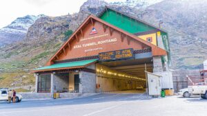
Such unforeseen environmental impacts are inherent in tunnelling. It is therefore critical that the long-term effects on local communities, historical sites, wetlands and ecologically sensitive areas are thoroughly assessed during the planning and feasibility stages.
The Kozhikode–Wayanad Tunnel passes through a region of exceptional ecological value, encompassing evergreen and semi-evergreen forests, shola grasslands, swamps and vital watersheds feeding the Chaliyar, Kabani and other rivers linking Wayanad and the Nilgiris.
Modern technology cannot accurately map all underground aquifers. Any disruption to these water sources could have severe, long-term consequences for communities downstream. Additional concerns include changes in surface land use, impacts on habitats, groundwater depletion or contamination, soil erosion and broader social consequences, particularly in the context of intensifying climate change. Common challenges in tunnel construction include difficulties in locating hydraulic heads, diversion of groundwater flows and water ingress into tunnels, all of which can dramatically escalate costs. Issues related to water rights also require careful consideration.
Proceeding with this project without rigorous, independent scientific studies and genuine public consultation risks turning the tunnel into a pathway not to development, but to lasting ecological disaster.








Development is essential, but it should never come at the cost of scientific evidence and ecological safety. This article raises important questions about risk assessment, accountability, and the need for transparent decision-making before undertaking major infrastructure projects in fragile regions.