

When the Water Towers Become Strategic Frontiers

Nepal’s Disaster, Asia’s Water Crisis — Part II:
The Himalayan crisis does not stop with melting glaciers. Across the Hindu Kush Himalaya, climate instability is colliding with dams, highways, tunnels, military infrastructure and geopolitical rivalry. As India and China compete along one of the world’s most fragile mountain systems, ecological security and national security are becoming dangerously intertwined.
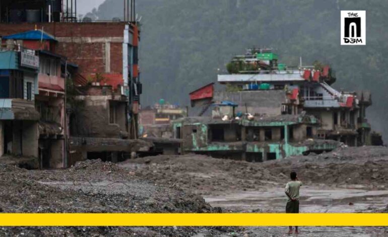
The catastrophe along the Nepal-China frontier in late August 2026 exposed one face of the Himalayan crisis: a rapidly changing cryosphere capable of unleashing devastating and cascading disasters.
But there is another dimension to the story.
The glaciers, rivers and mountain slopes of the Hindu Kush Himalaya are changing at precisely the moment when the region is witnessing an extraordinary expansion of strategic and civilian infrastructure. Roads are being widened, tunnels driven through mountains, hydropower projects constructed and military logistics networks pushed into increasingly remote terrain.

The convergence of these two processes — climatic destabilisation and intensive infrastructure expansion — could profoundly alter the risks confronting the Himalayas.
And because many of Asia’s great rivers cross national boundaries, those risks cannot be contained within the borders of any one country.
The Geopolitics of the Water Towers
While governments square off over border demarcations, military patrols and strategic outposts, another, less visible contest is unfolding around the rivers and ecosystems shared across national boundaries.
Since the middle of the twentieth century, rivalry between India and China has transformed large stretches of the Himalayas into a heavily militarised frontier. Roads capable of carrying troops and heavy equipment, bridges, tunnels, airfields, barracks and communications infrastructure have expanded on both sides of the disputed boundary.
Some of this infrastructure serves legitimate civilian, economic and security purposes. But large-scale construction in young, steep, tectonically active mountains inevitably carries environmental consequences. Road cutting, tunnelling, blasting, deforestation and slope modification can aggravate erosion and landslide susceptibility unless accompanied by stringent geological and environmental safeguards.
The same tension surrounds hydropower development.

China is developing major projects on the Tibetan plateau, including on the Yarlung Tsangpo, which becomes the Brahmaputra after entering India. India, meanwhile, has accelerated its own hydropower and infrastructure plans in the eastern Himalayas, partly because of energy requirements and partly because of strategic concerns about upstream Chinese development.
The result is an extraordinary concentration of planned infrastructure along ecologically sensitive river systems.
It would be an exaggeration to suggest that an upstream state can simply “turn off” a monsoon-dominated river such as the Brahmaputra. But control over the upper reaches of transboundary rivers does confer important advantages in hydrological information, dam operations and infrastructure planning.
And information matters immensely during a Himalayan emergency.
Real-time information about unusual river flows, glacier movement, landslides, temporary river blockages and reservoir releases can mean the difference between warning downstream communities and leaving them unaware of a rapidly approaching disaster.
The August catastrophe is therefore a reminder that transboundary data sharing is not an abstract matter of water diplomacy. It is potentially a matter of life and death.
Flood Today, Water Insecurity Tomorrow

The retreat of Himalayan glaciers creates another apparent paradox.
In the near term, increased melting can contribute to higher meltwater discharge in some river systems and intensify certain flood hazards. But glaciers are reservoirs, not inexhaustible sources of water. As their volume declines beyond particular thresholds, their capacity to sustain meltwater during dry seasons diminishes.
Scientists sometimes describe this transition as “peak water”: glacier-fed runoff initially rises as melting accelerates, reaches a maximum and then begins to decline as the ice reserve shrinks.

The timing and magnitude of this transition differ greatly from basin to basin. Monsoon rainfall, snowfall, groundwater, glacier melt and seasonal weather patterns contribute in different proportions to the Indus, Ganges, Brahmaputra and other river systems. It would therefore be misleading to portray the entire Himalayan region as following a simple sequence from floods to drought.
The larger danger nevertheless remains clear: rapid cryospheric change is making the region’s water cycle less predictable.
That uncertainty threatens agriculture, drinking-water supplies, hydropower production, fisheries and mountain ecosystems.
For communities living in the high Himalayas, the danger is more immediate still. Homes, farmland, grazing grounds and roads frequently occupy narrow valleys directly beneath unstable slopes, glaciers and glacial lakes. Many communities have contributed very little to global warming but find themselves on its front line.
When Strategic Frontiers Become Ecological Frontiers
There is another dimension that cannot be ignored.
The Himalayas contain some of the most politically sensitive borders on Earth. India and China remain locked in a strategic competition marked by unresolved territorial disputes and a sustained military presence. Pakistan, Nepal, Bhutan and Afghanistan occupy other parts of the wider Hindu Kush Himalayan system, each bringing its own political and developmental pressures.
This strategic geography encourages governments to view roads, dams, tunnels and communications systems primarily in terms of national power.
Ecology often becomes secondary.
To describe this as literal “ecological warfare” would be too simplistic. Neither India nor China deliberately causes glaciers to melt through its border policies, and global greenhouse-gas emissions remain the fundamental driver of Himalayan warming.

But militarisation and indiscriminate construction can compound environmental vulnerability.
Heavy infrastructure can fragment habitats, destabilise slopes and generate enormous quantities of construction waste. Mining and poorly regulated development can contaminate rivers and soils. Large dams and tunnelling can alter local hydrology and, in some circumstances, contribute to geological instability.
What they do not do is disturb some imagined “balance of the tectonic plates”. The Himalayas are intrinsically tectonically active because of the continuing collision between the Indian and Eurasian plates. The concern is more immediate: human interventions can amplify local instability in an already fragile geological environment.
The irony is striking. The very infrastructure constructed to establish strategic control over the Himalayas may become increasingly vulnerable to the environmental transformation of the mountains themselves.
The People Paying the Price
The language of geopolitics tends to focus on states: India, China, Nepal, Pakistan or Bhutan.
The consequences are experienced by people.
Farmers dependent on mountain streams, pastoralists using high-altitude grazing lands, workers building tunnels and dams, residents of narrow river valleys, pilgrims, trekkers and indigenous communities all inhabit a landscape whose risks are changing faster than many institutions can respond.

The August disaster provided a particularly stark illustration. Hundreds of workers were reported trapped in tunnels at hydropower projects after the floods struck, while a substantial portion of Nepal’s generating capacity was disrupted. Rescue teams from Nepal, India and China were deployed as authorities struggled with unstable terrain, damaged infrastructure and continuing flood risks. (Reuters)
The catastrophe thus exposed an uncomfortable contradiction at the heart of Himalayan development.
Infrastructure is often presented as the means through which remote mountain regions will become safer, richer and more connected. Yet infrastructure built without adequate understanding of rapidly changing mountain systems can itself create new concentrations of vulnerability.
This is not an argument for abandoning development.
It is an argument for recognising that the engineering assumptions of yesterday may no longer be adequate for the climate realities of tomorrow.
Science Cannot Stop at the Border
There is no technological solution capable of preventing every Himalayan disaster.
There are, however, measures that can dramatically reduce their human consequences.
Glacial lakes and unstable glaciers can be mapped. High-risk slopes can be monitored. River gauges and seismic networks can provide warning signals. Satellite observations can identify rapid changes in glaciers and lakes. Communities can be equipped with evacuation routes and communication systems. Hydropower projects can be subjected to climate-adjusted hazard assessments rather than evaluations based principally on historical conditions.
But none of these measures will be adequate if information stops at national borders.
China, India, Nepal, Bhutan, Pakistan and other countries of the HKH require stronger mechanisms for sharing hydrological, meteorological and cryospheric data. Early-warning protocols should operate across river basins rather than according to political geography.
Joint scientific programmes are particularly important because the scale of the Himalayan cryosphere exceeds the monitoring capacity of any single country.

ICIMOD and other research institutions have made important advances in glacier inventories, satellite monitoring and regional risk assessments. But scientific knowledge must translate into political cooperation, stronger regulation and local preparedness.
The challenge is no longer simply to understand what is happening to the Himalayas.
It is to act on that understanding.
A Warning from the Mountains
Nepal has lived with devastating floods and landslides before. The catastrophic monsoon disasters of 1993 killed more than a thousand people and remain embedded in the country’s collective memory.
But the emerging Himalayan risk landscape is different.
Climate change is now altering the glaciers, snowfields and permafrost upon which the physical stability and hydrology of the mountains depend. A disaster may begin with the collapse of a glacier, the failure of a moraine dam, an extreme rainfall event or a landslide — and then cascade rapidly across river systems, settlements and infrastructure.
The August 2026 catastrophe should therefore not be remembered merely as another flash flood.
It should be understood as a warning from a mountain system undergoing profound change.
Rising temperatures are destabilising glaciers and altering the hydrology of the Hindu Kush Himalaya. At the same time, roads, dams, tunnels, military installations and other large infrastructure are expanding across one of the world’s youngest, most seismically active and ecologically fragile mountain systems.

Climate change remains the overwhelming force transforming the Himalayan cryosphere. But the consequences of that transformation are shaped by political choices: where infrastructure is built, how rivers are engineered, whether environmental safeguards are enforced, and whether neighbouring countries share the information required to anticipate disasters.
The glaciers recognise no geopolitical borders.
Neither do debris flows, flash floods or droughts.
If governments continue to approach the Himalayas primarily as a strategic frontier and a reservoir of exploitable resources, ecological vulnerability will deepen. Competitive dam building and infrastructure expansion cannot substitute for basin-wide scientific cooperation.
The alternative is difficult but unavoidable: transparent hydrological data, joint scientific monitoring, rigorous environmental safeguards, regional disaster preparedness and an understanding that the ecological security of the Himalayas is inseparable from the human security of the countries surrounding them.
The future of Asia’s water towers may ultimately depend on whether the Himalayas cease to be treated merely as a frontier to be conquered and begin to be protected as a shared ecological system.
Read the Part I titled “Nepal’s Glacier Catastrophe and the Unravelling of Asia’s Water Towers” here










Prachi Jha’s piece makes a powerful point: the Himalayas cannot be treated merely as a strategic frontier or an endless resource zone. When climate change, militarisation, dams and unchecked infrastructure collide, it is ordinary people who bear the greatest cost. The glaciers recognise no borders—so neither should scientific cooperation, environmental responsibility and disaster preparedness. A timely and deeply important warning for all of Asia